Mt. Adatara

Mt. Adatara is a 1,700-meter peak on the western edge of the city of Nihonmatsu in Fukushima Prefecture. Its distinctive profile, floral beauty, and ready accessibility have made it a symbol of the region and a popular destination for hikers during warmer months.
A Geothermal Powerhouse
Mt. Adatara is part of a group of volcanoes that also includes Mt. Minowa and Mt. Tetsu. The massif was formed by volcanic activity that began around 500,000 years ago. Mt. Adatara took its current form roughly 200,000 years ago, and remains an active volcano today. The last major eruption was in 1900.
This volcanism has given the mountain rich deposits of sulfur and numerous hot springs. Both have attracted human interest for centuries, and neighboring towns like Dake Onsen still draw hot-spring water from the heights through many kilometers of pipes.
Beloved by Poets and Naturists Alike
Mt. Adatara is the northernmost mountain to receive mention in the eighth-century Man’yoshu, the oldest surviving anthology of Japanese poetry. More recently, it appeared in a celebrated 1927 verse by sculptor and poet Takamura Kotaro. Takamura’s wife Chieko, an artist and feminist, was born in Nihonmatsu, and in the poem he relates her insistence that the only “real sky” is the sky above Mt. Adatara. Yakushidake Panorama Park is one of many scenic lookouts in Fukushima inviting visitors to admire this “real sky.”
Mt. Adatara is not only cited as one of Japan’s “Hundred Great Mountains,” it was also included on a similar list of 100 mountains chosen for the beauty of their flora. Rhododendrons and azaleas are particularly prominent on its slopes, with dozens of varieties blooming in colors ranging from pale yellow to bright red.
Climbing Mt. Adatara
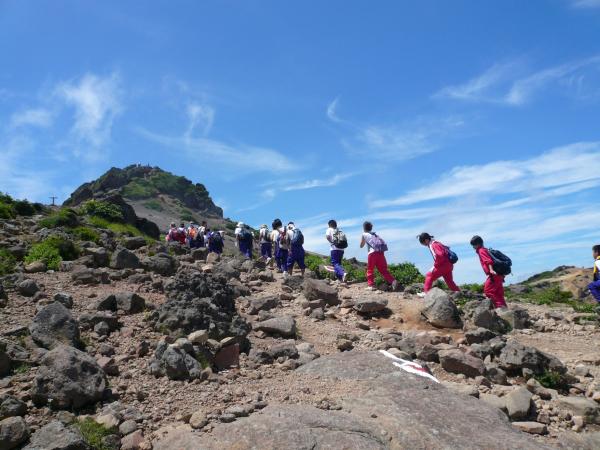
The most popular climbing route up Mt. Adatara begins at the Okudake Trailhead. It is a moderate half-day round trip requiring no special equipment. The first half of the route, from the trailhead to Yakushidake Panorama Park, can be replaced by a 10-minute ride on the Adatara Mountain Ropeway. The ropeway is only open during the “green season” from April to November. Climbing in other months is discouraged for those without winter mountaineering experience. Yakushidake Panorama Park has views of Mt. Kago and Mt. Tetsu to the northwest, and the city of Nihonmatsu and the Abukuma River to the east.
The second half of the route is a 2.4-kilometer climb from Yakushidake Panorama Park to the peak, taking about 75 minutes. The slope is gentle at first but steepens slightly after the Sennyodaira Fork, a landmark roughly at the halfway point. As the altitude rises, tall deciduous trees give way to spreading pines and low-lying bushes.
The rugged peak has unobstructed views of the surrounding landscape, including Mt. Osho to the south, Mt. Bandai and the Iide Range to the west, and the Azuma Range to the north. When the wind is not too strong, visitors can take another trail north to visit Numanotaira Crater and Mt. Tetsu before doubling back to return along the same route to the Okudake Trailhead.
The Four Seasons on Mt. Adatara

Mt. Adatara shows a different face with every season. The warmth of spring rises up the mountainside gradually, bringing forth delicate new leaves and blossoms in its wake. The earliest flowers to bloom include mayflowers and a rhododendron called urajiro yoraku, named for the flowers’ resemblance to the filigree-like hanging decorations known as yoraku that adorn Buddhist altars.

Summer, particularly from late June through July, is peak flower season on the mountain. Dozens of varieties of rhododendron and azalea come into bloom, with colors ranging from pale yellow to bright crimson. Varieties of thesarasa dodan bush with its bell-like flowers are also common. At higher altitudes, hardy dwarf corneland starflower bushes thrive amid the rocky terrain. Summer also brings chestnut tiger butterflies, which flit through the air on warm, still days.
Autumn descends from the peak to the foothills throughout October, with deeper colors at lower elevations. Japanese white pines produce needles that grow in distinctive clusters of five. Squirrels feast on the pine cones, leaving their cores under the trees. The mountain ashes and maple trees along the Mt. Adatara trail turn a brilliant red, while the dakekanba birch trees on the slopes of Mt. Tetsu to the north form a carpet of gold.

In winter, Mt. Adatara’s slopes are blanketed in snow. Climbing the mountain during this season without an experienced local guide is not recommended, and the Adatara Mountain Ropeway is closed all winter, but many visitors come to the ski resort and admire the view from below.
Yakushidake Panorama Park

Yakushidake Panorama Park is near the top of the Adatara Mountain Ropeway and can be accessed without any climbing. As the name suggests, it offers views of several peaks in the Adatara massif, as well as the city of Nihonmatsu and the Abukuma River to the east.
The view of Mt. Adatara’s peak rising to the west is marked with a sign that reads, “Real sky above this point.” This is a reference to a celebrated poem by Takamura Kotaro, in which his artist wife Chieko, who was born in Nihonmatsu but lived with him in Tokyo, declares that the only “real sky” is the sky above Mt. Adatara.
At the east end of the park is a lookout point with views of the surrounding landscape. To the northeast rise Mt. Kago, Mt. Tetsu, and Mt. Minowa, which are all part of the same volcano cluster as Mt. Adatara. Far to the north is the city of Fukushima; to the east is the urban center of Nihonmatsu, and beyond that the Abukuma River. To the south is Mt. Osho.
An iron bell hangs by the lookout point. This is a replica of the bell that Kurogane-goya Mountain Lodge, which stands on the slopes to the northwest, uses to signal to travelers when visibility is low due to fog. Visitors to Yakushidake Panorama Park are welcome to ring the bell and hear the iconic sound for themselves.
Numanotaira Crater

Numanotaira Crater is a volcanic crater northwest of Mt. Adatara’s peak. The crater is around 1.2 kilometers across and 150 meters deep. Descending into the crater itself is prohibited due to the risk of volcanic activity and poisonous fumes. It was formed by repeated eruptions over thousands of years. In the most recent eruption, in 1900, a sulfur refinery was destroyed and 72 miners working on the mountain died.
From the peak of Mt. Adatara, the closest point with a view of the crater is a 15-minute walk north along a broad ridge called the “Ox’s Back” (Ushi no se). The interior of the crater gradually comes into view along the way—a gouge in the mountainside almost completely devoid of vegetation.
A trail leads around the entire crater, but the full 7.4-kilometer circuit takes three or four hours to complete. Most visitors simply retrace their steps, with an optional detour to the peak of Mt. Tetsu and back. The Mt. Tetsu detour is an additional 30-minute walk north along the “Horse’s Back” (Uma no se), a ridge following the crater’s eastern edge that is slightly narrower than the “Ox’s Back” to the south.
The Peak of Mt. Adatara

Mt. Adatara’s peak is a rugged, windswept plateau with a mass of rock rising from the center. Although the summit is technically 1,699.7 meters above sea level, the signage rounds the figure to 1,700. When skies are clear, there are views of Mt. Osho to the south, Mt. Bandai and the Iide Range to the west, and the Azuma Range to the north. On especially clear days, climbers may even see as far as Mt. Aizu-Komagatake at the southwest end of Fukushima Prefecture.
The rocky ground of the peak is the accumulated result of hundreds of thousands of years of volcanic activity. This makes the individual rocks found there highly diverse in color, mineral content, and composition. Some rock formations show lines indicating multiple strata of magma laid down over the millennia.
The path up the central mass of rock to the very top of the mountain is one-way, with a separate trail for the descent to the plateau. This is the most challenging part of the climb, and requires caution, but metal ladders bolted to the rock assist in making the ascent safer and easier. There is a small shrine beside the summit marker, and another shrine to the deity of the mountain nestled beneath a ridge on the way down.
